COMMUNITY/COUNTY
HISTORY-PROFILE
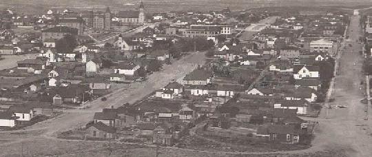
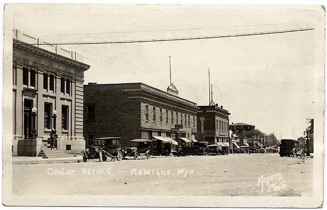
HISTORY OF RAWLINS
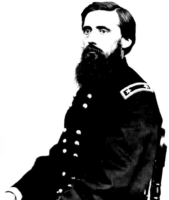 Gen.
John A. Rawlins
Gen.
John A. Rawlins
In 1867, while in command of the troops protecting the crew surveying the rout of the first trans continental railroad, General John A. Rawlins, Chief of Staff of the U.S. Army, expressed a wish for a drink of good, cold water.
A detachment of scouts explored the countryside as they rode west and approached the hills that stand guard over the present city they discovered a spring.
General Rawlins declared it was the most refreshing drink he had ever tasted and exclaimed, "If anything is ever named after me, I hope it will be a spring of water." General Grenville Dodge, commander of the survey party, immediately named it "Rawlins Springs" and the community that grew around it bore the same name. Later shortened to Rawlins, the town was incorporated in 1886 and designated the seat of Carbon County.
Created in 1868 by Dakota legislature, the county's name was derived from extensive coal deposits found in the area. Originally covering the entire width of the Wyoming Territory, Carbon County was reduced in size by the creation of Johnson County in 1875 and Natrona County in 1888. Historically it has been traversed by the Overland Trail, Oregon Trail, Mormon Trail and both the original route of the Union Pacific Railroad and the Lincoln Highway. Interstate 80 is now the "trail" of choice for most travelers through the county, although several scenic back-roads and by-ways offer pleasant alternatives.
CITY PROFILE
 Located on Interstate 80.
Rawlins and Carbon County are located in the
south-central portion of Wyoming and is the third largest county in Wyoming. Its
southern boundary is the Wyoming/Colorado border.
Located on Interstate 80.
Rawlins and Carbon County are located in the
south-central portion of Wyoming and is the third largest county in Wyoming. Its
southern boundary is the Wyoming/Colorado border.
The Continental Divide, which separates the eastern and western watersheds of North America, runs north and south through the county. Albuquerque, Billings, Boise, Denver and Salt Lake City are all within a 500 mile radius from Rawlins.
Rawlins is in the Mountain Standard time zone. The latitude is 41.791N. The longitude is -107.238W. Elevation is 6,827 feet. The estimated population, in 2006, was 9,006. The city is 8 square miles on 5,120 acres, the county is 7,991 square miles and 5, 114, 240 acres. The climate is semi-arid, low relative humidity. Annual precipitation is 10.9 inches average with snowfall at 41.5 inches. The average temperature is 42.2 degrees, summer average 67.6 degrees and winter average 35.8 degrees Fahrenheit, with a 100 to 112 day growing season.
Carbon County is one of 23 counties in Wyoming. The estimated population in 2006 was 15,271. This was a decrease of -2.35% from the 2005 census. In 2006, the per capita personal income in Carbon County was $25,432. This was an increase of 21.1% from 2005. The 2006 figure was 82% of the national per capita income, which was $30,906.
Parts of the Medicine Bow National Forest located in Carbon County offer a wide variety of year-round activities, The valley of the North Platte River in central Carbon County is one of the most productive livestock-raising areas in Wyoming. Wildlife abounds throughout the county and some of the finest fishing spots are just and easy drive away.
The Rawlins district of the Bureau of Land Management (BLM) administers over two million acres of public land in Carbon County. These lands are available for a variety of multiple uses including livestock grazing, mineral production and wildlife habitat. Recreation opportunities on public land in Carbon County including hunting, fishing, camping, snowmobiling, mountain biking, hiking and wildlife observation.
Western Carbon County contains the southern portion of the unique Great Divide Basin, which does not drain into any ocean. The county is a study in contrasts - from snow-capped mountains and high plateaus in the south and north, to vast prairie lands in the east and the Red Desert basin in the west. Elevations range from 5,000 feet in the Red Desert to 12,600 feet in the Snowy Range.
Carbon County contains active underground and strip coal mines and oil and gas fields. Sinclair Oil Refinery in Sinclair, is one of the largest refineries in the United States. Union Pacific Railroad provides freight hauling and dockside loading to industrial developments and Rawlins serves as a crew change point.
Rawlins is ranked No. 3 in the state, in the ePodunk Historic small towns index.
STATISTICS
| RAWLINS | WY | US | ||||||
| POPULATION | ||||||||
| Number | Number | Number | ||||||
| Total population | 9,006 | |||||||
| Square miles (land) | 7.40 | |||||||
| Population per square mile | 1,153.36 | 5.09 | 79.56 | |||||
| GENDER | ||||||||
| Number | Pct | Pct | Pct | |||||
| Male | 4,501 | 52.7 | 50.3 | 49.1 | ||||
| Female | 4,037 | 47.3 | 49.7 | 50.9 | ||||
| AGE | ||||||||
| Number | Pct | Pct | Pct | |||||
| 15 or younger | 1,761 | 20.6 | 20.9 | 21.4 | ||||
| 16-24 | 1,324 | 15.5 | 15.3 | 13.9 | ||||
| 25-44 | 2,512 | 29.4 | 28.1 | 30.2 | ||||
| 45-64 | 2,065 | 24.2 | 24.0 | 22.0 | ||||
| 65+ | 876 | 10.3 | 11.7 | 12.4 | ||||
| Number | Number | Number | ||||||
| Average age (years) | 35.70 | 36.27 | 36.22 | |||||
| RACE AND ETHNICITY | ||||||||
| Number | Pct | Pct | Pct | |||||
| White | 7,331 | 85.9 | 92.1 | 75.1 | ||||
| Black or African American | 69 | 0.8 | 0.8 | 12.3 | ||||
| American Indian and Alaska native | 125 | 1.5 | 2.3 | 0.9 | ||||
| Asian | 72 | 0.8 | 0.6 | 3.6 | ||||
| Native Hawaiian and other Pacific islander | 8 | 0.1 | 0.1 | 0.1 | ||||
| Some other race | 707 | 8.3 | 2.5 | 5.5 | ||||
| Two or more races | 226 | 2.6 | 1.8 | 2.4 | ||||
| Hispanic or Latino | 1,797 | 21.0 | 6.4 | 12.5 | ||||
| Sources: U.S. Census Bureau, 2000 Census; ePodunk | ||||||||
| RAWLINS | WY | US | ||||||
| CIVILIAN EMPLOYMENT BY INDUSTRY | ||||||||
| Number | Pct | Pct | Pct | |||||
| Manufacturing | 276 | 6.8 | 4.9 | 14.1 | ||||
| Wholesale trade | 70 | 1.7 | 2.3 | 3.6 | ||||
| Retail trade | 485 | 11.9 | 11.8 | 11.7 | ||||
| Information | 84 | 2.1 | 2.2 | 3.1 | ||||
| Finance and insurance | 108 | 2.6 | 3.1 | 5.0 | ||||
| Professional, scientific and technical services | 59 | 1.4 | 3.7 | 5.9 | ||||
| Table shows
selected industries Sources: 2000 Census, U.S. Census Bureau; ePodunk |
||||||||
| RAWLINS | WY | US | ||||||
| HOUSING UNITS | ||||||||
| Number | Number | Number | ||||||
| Total housing units | 3,896 | |||||||
| RENTER-OCCUPIED HOUSING UNITS | ||||||||
| Number | Pct | Pct | Pct | |||||
| Renter-occupied housing units | 1,084 | 27.8 | 26.0 | 30.8 | ||||
| Number | Number | Number | ||||||
| Average number of household members | 2.20 | 2.21 | 2.36 | |||||
| Average number of rooms | 4.45 | 4.46 | 4.04 | |||||
| Average number of vehicles | 1.32 | 1.51 | 1.19 | |||||
| Median year structure was built | 1968 | 1972 | 1969 | |||||
| Median year householder moved in | 1999 | 1999 | 1998 | |||||
| Median rent ($) | 314 | 373 | 519 | |||||
| Median rent asked for vacant units ($) | 326 | 358 | 469 | |||||
| Number | Pct | Pct | Pct | |||||
| Rent includes utilities | 241 | 22.2 | 27.7 | 16.5 | ||||
| Number | Number | Number | ||||||
| Rent as a pct of household revenue | 19.3 | 22.5 | 25.5 | |||||
| OWNER-OCCUPIED HOUSING UNITS | ||||||||
| Number | Pct | Pct | Pct | |||||
| Owner-occupied housing units | 2,259 | 58.0 | 60.5 | 60.2 | ||||
| Number | Number | Number | ||||||
| Average number of household members | 2.56 | 2.59 | 2.71 | |||||
| Average number of rooms | 6.44 | 6.54 | 6.30 | |||||
| Average number of vehicles | 1.69 | 1.62 | 1.64 | |||||
| Median year structure was built | 1963 | 1974 | 1971 | |||||
| Median year householder moved in | 1990 | 1992 | 1991 | |||||
| Median value ($) | 67,400 | 91,500 | 111,800 | |||||
| Number | Pct | Pct | Pct | |||||
| With mortgage or contract to purchase | 1,128 | 49.9 | 46.4 | 55.4 | ||||
| With second mortgage, equity loan | 279 | 12.4 | 10.3 | 12.7 | ||||
| Number | Number | Number | ||||||
| Median price asked for vacant housing ($) | 62,200 | 71,000 | 89,600 | |||||
| Monthly cost, with mortgage ($) | 681 | 825 | 1,088 | |||||
| Monthly cost, without mortgage ($) | 190 | 229 | 295 | |||||
| Sources: U.S. Census Bureau, 2005 Census; ePodunk | ||||||||
Home - Business Index - Relocation Guide - Visitors Guide