INDEPENDENCE ROCK
PARK HISTORY
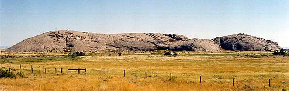
Register of the Desert
This granite monolith is one of the more famous landmarks along the Oregon Trail and has served as a meeting place since the area was first inhabited. Independence Rock was an important place for the Native Americans who first lived here. This giant igneous formation of feldspar and mica found its way into many native legends and later into the diaries of many westbound pioneers.
The first Europeans to visit the rock were members of Robert Stuart's expedition in 1812. It is Stuart who is generally credited with the discovery of the route, which became known as the Oregon Trail. Stuart's diary indicated he visited the site on October 30, 1812. Stuart however, did not name this giant rock. That honor went to William Sublette, who held an Independence Day celebration on July 4, 1830, as he led the first wagon train to cross the new overland route. Before and audience of 80 or so pioneers he christened the rock in honor of the birth date of the United States.
Independence Rock is most famous for the names inscribed on its face: the names and dates of people who passed by this place in search of a new life in the frontier. It was the names carved in stone that caused Father Peter J. DeSmet to appropriately name this place "The Register of the Desert" in 1840.
As you walk around the rock you will see hundreds of names carved or chipped into the surface. Possibly one of the earliest signatures to be found here is that of "M.K. Hugh 1824."
Facts and Figures
Independence Rock stands 6, 028 feet (1.808.3 m) above sea level. The rock's tallest point is 136 feet (40.8 m) above the surrounding terrain. The distance around the base of the rock is more than a mile or 5,900 feet (1.8 km). Independence Rock's mass is equal to an area of 24.81 acres (9.924 ha).
Many people believe that the shape of this highly polished round outcropping was created by glaciers. Actually, a process known as "exfoliation" is how the rock got its sleek, round form.
As Independence Rock was slowly uncovered by erosion, the immense pressures of the weight of overlaying rock were gradually lessened. The Rock then expanded outwardly, shedding its surface layers like an onion. Layers of granite gradually broke off and formed the now rounded shape.
Windblown sand and silt have grooved the rock and polished it to a high gloss in a process called "windfaceting." This smooth surface enabled pioneers to carve their names into the rock.
Trappers, emigrants, traders, religious leaders, followers - and just about everybody else who passed this way walked around and all over this turtle-shell outcropping of granite. That means that just about every person of the 550,000 or so estimated to have used the Oregon Trail marveled at this unique formation.
Each wagon heading west tried to time its start so the spring grass would be sufficient to support the animals without delaying too long to risk the early snows in the mountains. Consequently everyone was on the trail at the same time.
Emigrants would race to arrive at the rock by the Fourth of July. A huge celebration would then take place upon their arrival with sounds of gunfire, boisterous drinking and patriotic oration.
One of the myths of the Oregon Trail was that groups of hostile Natives preyed upon the emigrants. Out of all the wagon trains that traversed on the trail, only 350 people out of many hundreds of thousands were killed by Native attacks.
Why the natives did not bother the pioneers at Independence Rock is only a guess. The area seemed to a "neutral zone," even though a diary accounts of pioneers relate tales of wandering bands of natives who would trail by the rock at times.
Prominent Features
To the west are several prominent natural features once used as trail guides. Following Wyoming 220 South to your right you will notice the Sweetwater River making an abrupt turn. At the point where the river flows through a granite ridge is the location of Devils Gate. The river has cut a chasm 330 feet deep. It is 400 feet wide at the top, but only 30 feet wide at the bottom.
Twenty miles south of Independence Rock is the Muddy Gap intersection. Turn North on Wyoming 789/ US 287 and eight miles down the road you will find another famous landmark, known as Split Rock. Its summit is 7,305 feet. The notch resembles a gun sight when viewed from either east or west, and is visible for more than 50 miles.
State Park Reservations
• Reservations can be made by calling the reservation center at 877-996-7275 or going online to www.wyo-park.com. Reservations can also be cancelled online, but other changes must be made through the reservation center.
• Reservations can be made for arrival dates through September 30 by calling 877-996-7275 or going online to www.wyo-park.com.
• A three-night stay is required on holiday weekends at all parks, for reservable sites.
• Several sites may be reserved with a single call, but payment of reservation fees for all sites is required before confirmation is made.
• Reservations may be made at the following locations: Boysen, Buffalo Bill, Curt Gowdy, Glendo, Guernsey and Keyhole State Parks and Medicine Lodge State Archaeological Site.
• Campsite reservations are accepted up to 90 days prior to your arrival at the above listed locations. Campsites may be reserved for arrival dates between May 16 and September 30.
• The reservation center is open 7 a.m. to 9 p.m. daily (MST) from January 2 to September 30. Online reservations can be made 24 hours a day, but sites cannot be reserved ahead of the time they become available at the reservation center. The reservation center is closed all other times.
• Reservations are accepted as few as two days prior to the arrival when using a credit card, or 10 days for other payment methods. Wednesday is the last day to reserve a site for the upcoming Friday and/or Saturday.
• Reservation fees must be paid when reservations are made. Credit card, money order or personal checks are accepted. Only one payment is accepted for multiple-site reservations. Non-credit card payments must be received within five days after making a reservation.
Send payments
to:
Daksoft, Inc.
P.O. Box 1400
Rapid City, SD 57709-1400
• There is an $8.50 per site non-refundable reservation fee.
• A $5 cancellation fee will be charged for each campsite reserved if you cancel any part of your reservation by phone. Reservations may be cancelled after arriving at the park. Please see the Park Superintendent for questions on day use and camping fee refunds.
• If two camping units share a site, each unit must pay the camping fee. A camping unit is a powered vehicle, motor home, camping bus, pull-type camper, tent or any other device designed for sleeping. Additional tents for a family (parents or grandparents and unmarried minor children) are considered a single camping unit.
• If you plan on camping in one of the sites managed by the Wyoming State Parks & Historic Sites, you must pay both a daily use fee and a camping fee. These fees are payable at the location you visit. Eighty percent of your fees goes directly back to the parks and sites for improvements.
Park Fees
Season/Closures: grounds and facilities open year round, weather permitting
Hours: site grounds open 24 hours
Site Features and/or Visitor Use Improvements: drinking water, historic features, picnic areas, rest area, restrooms, telephone, trailer sanitary station, trails, visitor center
Staffed: Seasonally
Restrictions: Overnight camping by permit only; basic rules & regulations
Fees: None
PARK RULES
No defacing or writing on the rock
No gathering of artifacts (anything found must be left there or turned over to a State Park official on site)
Metal detectors are not allowed
Fireworks and firearms are prohibited
Digging is prohibited
Destroying or removing of any tree, shrub or plant is prohibited
Drive and park vehicles in designated areas
All pets must kept on a leash
No killing of wildlife including rattlesnakes
Please pack out your own trash
Overnight camping by special use permit only*
Independence Rock State Historic Site *
| Superintendent | Address | Locations | Phone | |
| Rick Anderson | PO Box 1596 | Evansville, WY 82636 | 307.577.5150 | c/o Edness K Wilkins State Park |
Independence Rock is administered by the Division of State Parks and Historic Sites, Wyoming Department of State Parks and Cultural Resources http://wyospcr.wy.us/
Visitors Guide - Wyoming Travel Information
The Carbon County Visitors Counsel is located in Riverside, Wyoming off HWY 70. Click on the picture for more information on things to do in Carbon County.