HUNTING GUIDE
HUNTING AREAS
Antelope
Area
48. Leo-Hanna.
Beginning at the junction of Wyoming Highway 72 and Interstate Highway
80; westerly along Interstate Highway 80 to the North Platte River; northerly
down said river to Canyon Creek; easterly up said creek to the south fork of
Canyon Creek; southerly and easterly up said fork to the Dry Creek Road (Carbon
County Road 103); southerly along said road to the Leo-Shirley Basin Road
(Carbon County Road 102); southwesterly along said road to Pryor Flat and the
BLM Fire Camp Road (BLM Road 3115); southeasterly along said road to the
Troublesome Spring Road; southerly along said road to Troublesome Creek;
southerly along said creek to the Hanna-Leo Road (Carbon County Road 291);
southerly along said road to the town of Hanna and Wyoming Highway 72; southerly
along said highway to Interstate Highway 80.
Area
50. Elk Mountain.
Beginning where Interstate Highway 80 crosses the North Platte River;
easterly along said highway to Rock Creek at Arlington; southerly up said creek
to Deep Creek; southwesterly up said creek to the divide between the Laramie
River and the North Platte River; southerly along said divide to Wyoming Highway
230; southwesterly along said highway to the Wyoming-Colorado state line; west
along said line to the North Platte River; northerly down said river to
Interstate Highway 80.
Area
51. Big Creek.
Beginning where the North Platte River crosses the Wyoming-Colorado state
line; west along said line to the Encampment River; northeasterly down said
river to the North Platte River; southerly up said river to the Wyoming-Colorado
state line.
Area
52. Spring Creek.
Beginning where the Continental Divide crosses the Wyoming-Colorado state
line; northerly along said divide to the Sage Creek Road (Carbon County Road
401); northerly along said road to Sage Creek; northeasterly down said creek to
the North Platte River; southerly up said river to the Encampment River;
southwesterly up said river to the Wyoming-Colorado state line; westerly along
said line to the Continental Divide.
Area
53. Baggs.
Beginning at the junction of Wyoming Highway 789 and the Wyoming-Colorado
state line; northerly along said highway to Muddy Creek north of the town of
Dad; easterly up said creek to the Muddy Creek Road (BLM Road 3306); easterly
along said road to the Miller Hill Road (BLM Road 3328); southeasterly along
said road to the McCarty Canyon Road (Carbon County Road 503); northeasterly
along said road to the Rawlins City Water Works Road; northerly along said road
to Sage Creek below Sage Creek Reservoir; northeasterly down said creek to the
Sage Creek Road (Carbon County Road 401); southerly along said road to the
Continental Divide at Middlewood Hill; southerly along said divide to the
Wyoming-Colorado state line; west along said line to Wyoming Highway 789.
Area
55. Red Rim.
Beginning at the city of Rawlins; southerly along Wyoming Highway 71 to
the divide along Five Mile Ridge; southwesterly along the divide on Five Mile
Ridge and Atlantic Rim to the crossing of the Sulphur Springs Ranch Road over
Muddy Creek; westerly down said creek to Wyoming Highway 789; northerly along
said highway to Interstate Highway 80; easterly along said highway to the city
of Rawlins.
Area
56. Iron Springs.
Beginning at the city of Rawlins; easterly along Interstate Highway 80 to
the North Platte River; southerly up said river to Sage Creek; southwesterly up
said creek to the Sage Creek Road (Carbon County Road 401); northerly along said
road to Wyoming Highway 71; northerly along said highway to the city of Rawlins.
Area
57. South Wamsutter.
Beginning at the junction of Wyoming Highway 789 and the Wyoming-Colorado
state line; westerly along said line to the Cow Creek-Powder Wash Road north of
Powder Wash, Colorado; northwesterly along said road to the Bitter Creek Road
(Sweetwater County Road 19); northwesterly along said road to Interstate Highway
80; easterly along said highway to Creston Junction and Wyoming Highway 789;
southerly along said highway to the Wyoming-Colorado state line.
Area
58. Black Butte-Kenny Rim.
Beginning at the junction of Wyoming Highway 430 and the Wyoming-Colorado
state line; northwesterly along said highway to Interstate Highway 80 in the
town of Rock Springs; easterly along said highway to the Bitter Creek Road
(Sweetwater County Road 19); southeasterly along said road to the Carson Springs
Junction and the Cow Creek-Powder Wash Road; southeasterly along said road to
the Wyoming-Colorado state line; westerly along said line to Wyoming Highway
430.
Area
61. Chain Lakes.
Beginning at the city of Rawlins; westerly along Interstate Highway 80 to
the Wamsutter-Crooks Gap Road (Sweetwater County Road 23 and Fremont County
Road); northerly along said road to Crooks Gap and the divide along Green
Mountain; southeasterly along said divide to Whiskey Peak and the head of Coal
Creek; northeasterly down said creek to U.S. Highway 287; southerly along said
highway to the city of Rawlins.
Area
62. South Ferris.
Beginning at the city of Rawlins; northerly along U.S. Highway 287 to
Muddy Gap Junction and the divide along the Ferris Mountains; southeasterly
along said divide to Ferris Peak and the northeast branch of the Continental
Divide; southeasterly along said branch to Bradley Peak and the divide along the
Seminoe Mountains; easterly along said divide to Seminoe Dam and the North
Platte River; southerly up said river to Interstate Highway 80; westerly along
said highway to the city of Rawlins.
Area 63. North Ferris. Beginning at Muddy Gap Junction; northeasterly along Wyoming Highway 220 to the Kortes Road (Natrona County Road 407); southerly along said road to the North Platte River; southerly up said river to Seminoe Dam and the divide along the Seminoe Mountains; westerly along said divide to Bradley Peak and the northeast branch of the Continental Divide; northwesterly along said divide to Ferris Peak and the divide along the Ferris Mountains; northwesterly along said divide to Muddy Gap Junction.
Deer
Area
70.
Area
75. Four
Mile. Beginning
at the city of Laramie and Wyoming Highway 130; westerly along said highway to
the divide between the Laramie River and the North Platte River; northerly along
said divide to Medicine Bow Peak and the divide between the Medicine Bow River
and Brush Creek; northeasterly along said divide to the North Brush Creek Road (U.S.F.S
Road 100); northerly along said road to the Sand Lake Road (U.S.F.S. Road 101);
northwesterly along said road to the Cedar Pass Road (U.S.F.S. Road 261);
southwesterly along said road to U.S.F.S. Road 115; northerly along said road to
the Pass Creek Basin Road; northerly along said road to the Pass Creek Road
(Carbon County Road 404); northerly along said road to Wyoming Highway 72;
northwesterly along said highway to Interstate Highway 80 to the west Elk
Mountain interchange; southeasterly along said highway to Wyoming Highway 130.
Area
79.
Area
80. Spring
Creek.
Beginning at the Continental Divide on Wyoming Highway 70; northerly
along said divide to the Rawlins-Sandstone Road; northerly along said road to
Sage Creek; northeasterly down said creek to the North Platte River; southerly
up said river to the town of Saratoga and Wyoming Highway 130; southerly along
said highway to Wyoming Highway 230; southerly along said highway to Wyoming
Highway 70 at the town of Riverside; southwesterly along said highway to the
Continental Divide.
Area
81. Blackhall.
Beginning at the Wyoming-Colorado state line and Wyoming Highway 230;
westerly along said line to the Continental Divide; northerly along said divide
to Wyoming Highway 70; northeasterly along said highway to Wyoming Highway 230
at the town of
Area
82. Baggs.
Beginning at the junction of Wyoming Highway 789 and the Wyoming-Colorado
state line; northerly along said highway to Muddy Creek north of Dad; easterly
up said creek to the Muddy Creek Road (BLM Road 3306); easterly along said road
to Miller Hill Road (BLM Road 3328); southeasterly along said road to McCarty
Canyon Road (Carbon County Road 503); northeasterly along said road to Rawlins
City Water Works Road; northerly along said road to Sage Creek below Sage Creek
Reservoir; northeasterly down said creek to Sage Creek Road (Carbon County Road
401); southerly along said road to the Continental Divide at Middlewood Hill;
southerly along said divide to the
Wyoming‑Colorado state line; westerly along said line to Wyoming
Highway 789.
Area
83. Bolten
Rim.
Beginning at the city of
Area
84. Atlantic
Rim. Beginning
at the city of Rawlins; southerly along Wyoming Highway 71 to the Sage Creek
Road (Carbon County Road 401); southerly along said road to Sage Creek;
southwesterly up said creek to the Rawlins City Water Works Road below Sage
Creek Reservoir; southerly along said road to the McCarty Canyon Road (Carbon
County Road 503); southwesterly along said road to the Miller Hill Road (BLM
Road 3328); northwesterly along said road to the Muddy Creek Road (BLM Road
3306); westerly along said road to Muddy Creek; westerly down said creek to
Wyoming Highway 789; northerly along said highway to Interstate Highway 80;
easterly along said highway to the city of Rawlins.
Area 87. Ferris. Beginning at the city of Rawlins; northerly along U.S. Highway 287 to Muddy Gap Junction and Wyoming Highway 220; northeasterly along said highway to the Pathfinder Road (Natrona County Road 409); southerly along said road to the Pathfinder Dam service road; southerly along said road to the North Platte River at Pathfinder Dam; southerly up said river to Interstate Highway 80; westerly along said highway to the city of Rawlins.
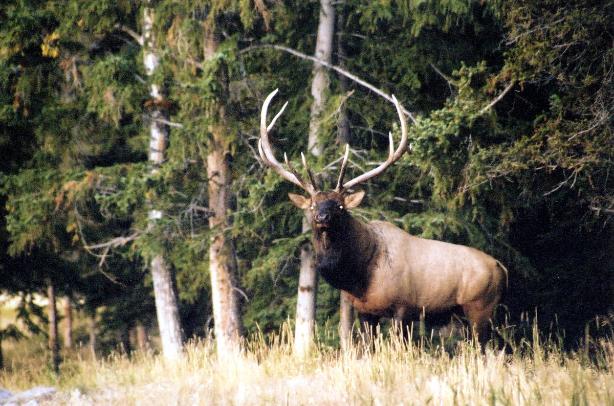
Elk
Area
21. Baggs.
Beginning at the junction of Wyoming Highway 789 and the
Wyoming‑Colorado state line; northerly along said highway to Muddy Creek
north of Dad; easterly up said creek to the Muddy Creek Road (BLM Road 3306);
easterly along said road to Miller Hill Road (BLM Road 3328); southeasterly
along said road to the McCarty Canyon Road (Carbon County Road 503);
northeasterly along said road to the Rawlins City Water Works Road; northerly
along said road to Sage Creek below Sage Creek Reservoir; northeasterly down
said creek to the Sage Creek Road (Carbon County Road 401); southerly along said
road to the Continental Divide at Middlewood Hill; southerly along said divide
to the Wyoming‑Colorado state line; westerly along said line to Wyoming
Highway 789.
Area 22. Ferris. Beginning at Muddy Gap Junction; northeasterly along Wyoming Highway 220 to the Buzzard Road (Natrona County Road 410‑Carbon County Road 497); southerly along said road to the South Ferris Road (Carbon County Road 100); westerly along said road to U.S. Highway 287; northerly along said highway to Muddy Gap Junction.
Area
24. Green Mountain.
Beginning at Muddy Gap Junction; southerly along U.S. Highway 287 to the
town of Lamont; westerly along Wyoming Highway 73 to the Bairoil Road
(Sweetwater County Road 22); westerly along said road to the Wamsutter-Crooks
Gap Road (Sweetwater County Road 23); northerly along said road to the Three
Forks‑Atlantic City Road (BLM Road 2317); westerly along said road to the
Bison Basin Road (BLM Road 3221); northerly along said road to U.S. Highway 287;
easterly along said highway to Muddy Gap Junction.
Area
124. Powder Rim.
Beginning at the junction of Wyoming Highway 789 and the
Wyoming‑Colorado state line; westerly along said line to Wyoming Highway
430; northerly along said highway to Interstate Highway 80; easterly along said
highway to Wyoming Highway 789; southerly along said highway to the Wyoming-Colorado
state line.
Area
125. Elk Mountain.
Beginning at the junction of Interstate Highway 80 and U.S. Highway 30 at
the Saratoga interchange; northeasterly along U.S. Highway 30 to Wyoming Highway
72 at the Hanna interchange; southeasterly along Wyoming Highway 72 to the Pass
Creek Road (Carbon County Road 404) west of the town of Elk Mountain; southerly
and westerly along said road to Wyoming Highway 130; northerly along said
highway to Interstate Highway 80.
Mountain Lion
Area
7. Snowy Range.
Beginning at the town of Medicine Bow and U.S. Highway 287; easterly and
southerly along said highway to the Wyoming-Colorado state line; westerly along
said line to Wyoming Highway 230 (west of the North Platte River); northerly
along said highway to Wyoming 130; northerly along said highway to U.S. Highway
287; northeasterly along said highway to the town of Medicine Bow.
Area
8. Seminoe.
Beginning at the junction of Wyoming Highway 220 and Wyoming Highway 487;
southerly along Wyoming Highway 487 to U.S. Highway 287; westerly along said
highway to Interstate Highway 80; westerly along said highway to U.S. Highway
287 in the city of Rawlins; northerly along said highway to Wyoming Highway 220;
northeasterly along said highway to Wyoming Highway 487.
Area
9. Sierra Madre.
Beginning at the junction of Interstate Highway 80 and Wyoming Highway
130; southerly along Wyoming Highway 130 to Wyoming Highway 230; southeasterly
along said highway to the Wyoming‑Colorado state line; westerly along said
line to the Continental Divide; northerly along said divide to the Sage Creek
Road (Carbon County Road 401); northerly along said road to Wyoming Highway 71;
northerly along said highway to Interstate Highway 80; easterly along said
highway to Wyoming Highway 130.
Area 10. Haystacks.
Beginning at the junction of Interstate Highway 80 and the Bitter Creek
Road (Sweetwater County Road 19); easterly along Interstate Highway 80 to the
junction of Wyoming Highway 71; southerly along said highway to the Sage Creek
Road (Carbon County Road 401); southerly along said road to the Continental
Divide at Middlewood Hill; southerly along said divide to the Wyoming-Colorado
state line; westerly along said line to the Cow Creek-Powder Wash Road north of
Powder Wash, Colorado; northwesterly along said road to the Bitter Creek Road;
northerly along said road to Interstate Highway 80.
Carbon County Outfitters
|
Name |
Location | Address |
Phone |
|
| Antelope-Deer Hunts Outfitters | Rawlins | PO Box | 307.321.1076 | regm@vcn.com |
| Grand Slam Outfitters | Saratoga | N/A | N/A | mark@grandslamoutfitters.net |
| Platt's Guides and Outfitters | Encampment | Star Route Box 49 | 307.327.5539 | maplatt@Union-Tel.com |
| Savery Creek Outfitters | Savery | PO Box 189 | 307-383-7117 | sco@wyoming.com |
| Spur Outfitters LLC | Encampment | PO Box 714 | 307.327.6505 | spuroutfitters@carbonpower.net |
| Trophy Room Outfitters | Saratoga | 106 Deer Drive | 307.326.9613 | huntpronghorn@yahoo.com |
| Wycon Safari Inc | Saratoga | PO Box 1126 | 307.327.5502 | bmcondict@union-tel.com |
Visitors Guide - Wyoming Travel Information
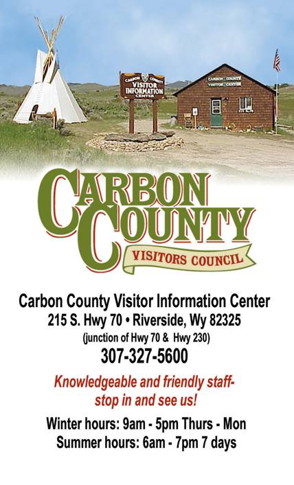
The Carbon County Visitors Counsel is located in Riverside, Wyoming off HWY 70. Click on the picture for more information on things to do in Carbon County.